
Bighorn Fire Updates
Posted: 17 June 2020
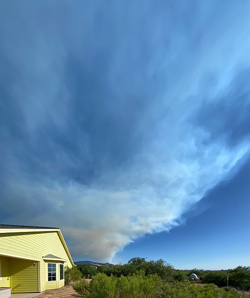
Sunday, 14 June 2020, dawned clear with very little smoke from the Bighorn Fire (15 miles south). The fire had burned 12,345 acres and was 11% contained since it was started by lightning on Friday, 5 June. By mid-morning, as the wind picked up, smoke was visible in most of the sky. This wide-angle iPhone photo taken late Sunday afternoon shows some of the smoke in the sky over Cassiopeia Observatory.
Monday, 15 June, began clear with some smoke. The Bighorn Fire was 14,675 acres with 22% containment. The fire is burning up the mountain and moving northward, and may threaten Mt Lemmon Observatory (about 11 miles away). By mid-morning smoke was visible in most of the sky at Cassiopeia Observatory. Smoke decreased during the day but clouds increased as Monsoon Season began. This 10 seconds exposure photograph was taken at 2141 MST Monday night. Smoke illuminated by the fire is clearly seen along with some stars through the smoke.

Click or tap on image for larger version
Tuesday, 16 June, dawned clear but with smoke visible in much of the sky. The Bighorn fire had burned 15,805 acres and was now 30% contained. For perspective I took these photos of Mt Lemmon showing where the fire was the previous night (at the right) and the observatory domes (left).
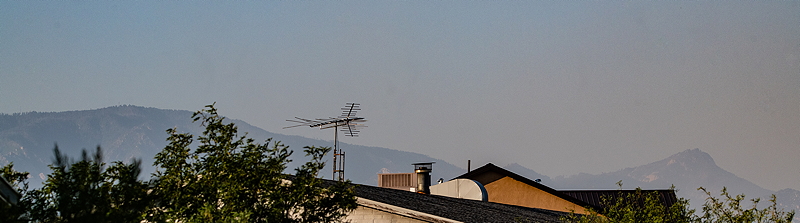
Mt Lemmon observatories

Click or tap on image for larger version
About 1400 MST on Tuesday the fire became a serious threat to Mt Lemmon Observatory and the community of Summerhaven so evacuations were ordered. This was the view from Oracle.

Click or tap on image for larger version
The sky looked to be clearing as sunset approached but then clouds and more smoke appeared. This photo was taken about 2100 MST and shows the Omega Centauri globular cluster over the Bighorn Fire.

Click or tap on image for larger version
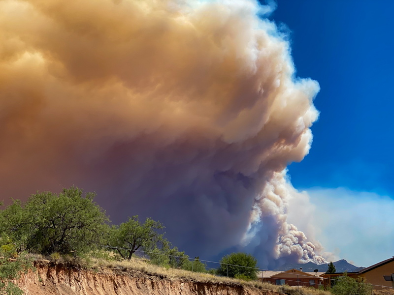
Wednesday, 17 June, began clear and calm with very little smoke in the sky. The fire was reported as 17,492 acres and 40% contained. Strong winds were expected to increase during the day, as they have almost every day since the fire started. Wednesday afternoon the smoke column from the fire definitely looked bad. At times it looked like a nuclear bomb went off. I could see the smoke roiling at the ground.
I took this panoramic photo about an hour before sunset from near the observatory. The view is from the North (left) to the East (center) to the South (right). The smoke had moved further eastward so looked less ominous. But there was still strong winds blowing.

About sunset the fire acreage burnt had increased dramatically during the day to 23,892. Not surprising given the explosive growth in the smoke coverage during the day. By about 2000 MST the fire had moved a little more northward and had topped the ridge line seen in the previous photos. I took these photos.

Click or tap on image for larger version

Click or tap on image for larger version
Oracle was placed in a SET to evacuate order Wednesday night. We packed up. In case I don't post reports for awhile, it is because we have evacuated.
A live view from Mt Lemmon Observatory may be available via the SkyCenter webcam. The electricity was turned off on the mountain late Wednesday afternoon so the images may not be available.
Comments are welcome using Email. Twitter users can use the button below to tweet this report to their followers. Thanks.
Cassiopeia Observatory Home Page
Copyright ©2020 Michael L. Weasner / mweasner@me.com
URL = http://www.weasner.com/co/Reports/2020/06/17/index.html